Alert Details
Alert Information 0.0% County Coverage
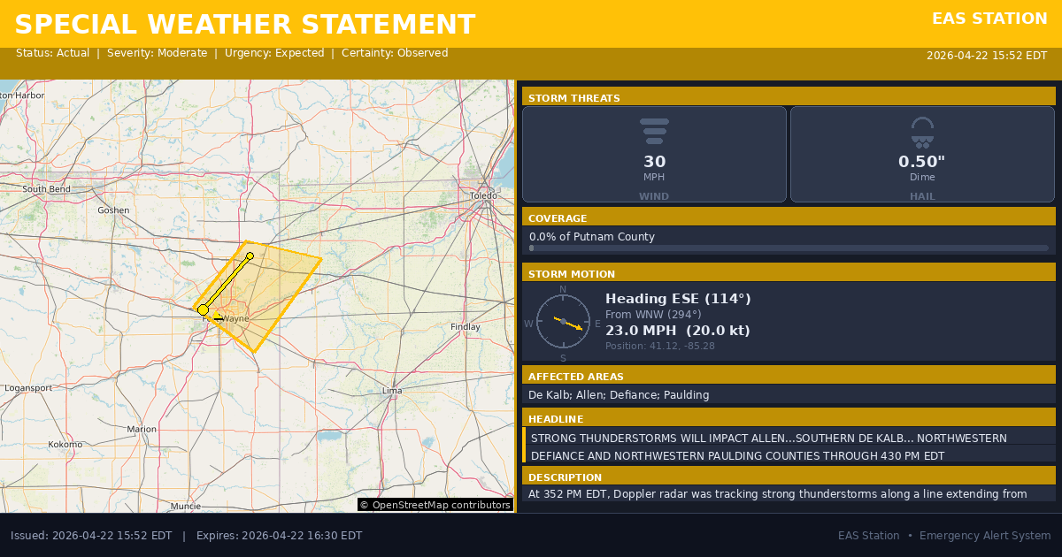
Special Weather Statement issued April 22 at 3:52PM EDT by NWS Northern Indiana
Event Type
Special Weather StatementStatus
Actual EXPIREDSeverity
ModerateUrgency
ExpectedCertainty
ObservedMessage Type
AlertDescription
At 352 PM EDT, Doppler radar was tracking strong thunderstorms along a line extending from near Auburn to 8 miles south of Churubusco. Movement was southeast at 25 mph.
HAZARD...Winds in excess of 30 mph and half inch hail.
SOURCE...Radar indicated.
IMPACT...Gusty winds could knock down tree limbs and blow around unsecured objects. Minor hail damage to vegetation is possible.
Locations impacted include... Fort Wayne, New Haven, Auburn, Garrett, Hicksville, Butler, Huntertown, Waterloo, Antwerp, Woodburn, Grabill, St. Joe, Leo-cedarville, Concord, Newville, Butler Center, Saint Johns, Spencerville In Dekalb County, Zulu, and Moore.
This includes the following highways... Interstate 469 between mile markers 13 and 30. Interstate 69 in Indiana between mile markers 305 and 329.
Instructions
If outdoors, consider seeking shelter inside a building.
Affected Areas
018033
DeKalb County, IN
018003
Allen County, IN
039039
Defiance County, OH
039125
Paulding County, OH
INZ009
INZ018
OHZ004
OHZ015
This covers a small portion of emergency service districts, townships, and municipalities within the county.
Alert Coverage Map
Loading map...
Loading alert coverage map...Timing
03:52 PM EDT
04:30 PM EDT
03:53 PM EDT
05:25 PM EDT
Times in America/New_York. Auto-adjusts for daylight saving.
Technical Details
urn:oid:2.49.0.1.840.0.8b4e266a655599d63ae663ce36d8fb4dc2ac1afd.001.1
#530
Source times converted from NWS format to local Eastern Time.
Affected Boundaries
Localized County Impact
This alert covers 0.0% of Putnam County , affecting some emergency service boundaries.
No Boundary Intersections Found
This alert may not intersect with any configured emergency service boundaries.
NOAA Alert Details
Alert Origin
w-nws.webmaster@noaa.gov
en-US
https://api.weather.gov/alerts/active?zone=OHC003,OHZ016,OHC137,OHZ025,OHZ004,OHC039,OHZ017,OHC063,OHZ005,OHC069,OHZ015,OHC125,OHZ024,OHC161,OHZ006,OHC173
NOAA
EAS Parameters
WXR
— National Weather Service
Geocodes
018033
DeKalb County, IN
018003
Allen County, IN
039039
Defiance County, OH
039125
Paulding County, OH
INZ009
INZ018
OHZ004
OHZ015
INZ009
INZ018
OHZ004
OHZ015
Event Codes
SPS
SPS
Storm Motion
Severe Threats
NWS Parameters
SPSIWX
WWUS83 KIWX 221952