Alert Details
Alert Information 0.0% County Coverage
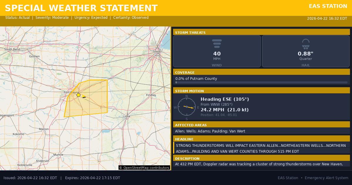
Special Weather Statement issued April 22 at 4:32PM EDT by NWS Northern Indiana
Event Type
Special Weather StatementStatus
Actual EXPIREDSeverity
ModerateUrgency
ExpectedCertainty
ObservedMessage Type
AlertDescription
At 432 PM EDT, Doppler radar was tracking a cluster of strong thunderstorms over New Haven, moving east at 25 mph.
HAZARD...Wind gusts up to 40 mph and nickel size hail.
SOURCE...Radar indicated.
IMPACT...Gusty winds could knock down tree limbs and blow around unsecured objects. Minor hail damage to vegetation is possible.
Locations impacted include... Fort Wayne, New Haven, Van Wert, Bluffton, Decatur, Ossian, Paulding, Antwerp, Woodburn, Monroeville, Payne, Convoy, Grabill, Middletown, Middlebury, Preble, Dixon, Grover Hill, Uniondale, and Scott.
This includes Interstate 469 between mile markers 1 and 2, between mile markers 4 and 6, and between mile markers 9 and 27.
Instructions
If outdoors, consider seeking shelter inside a building.
Affected Areas
018003
Allen County, IN
018179
Wells County, IN
018001
Adams County, IN
039125
Paulding County, OH
039161
Van Wert County, OH
INZ018
INZ026
INZ027
OHZ015
OHZ024
This covers a small portion of emergency service districts, townships, and municipalities within the county.
Alert Coverage Map
Loading map...
Loading alert coverage map...Timing
04:32 PM EDT
05:15 PM EDT
04:34 PM EDT
06:08 PM EDT
Times in America/New_York. Auto-adjusts for daylight saving.
Technical Details
urn:oid:2.49.0.1.840.0.cc51d726bb8e332baf849319489a831676572f1f.001.1
#534
Source times converted from NWS format to local Eastern Time.
Affected Boundaries
Localized County Impact
This alert covers 0.0% of Putnam County , affecting some emergency service boundaries.
No Boundary Intersections Found
This alert may not intersect with any configured emergency service boundaries.
NOAA Alert Details
Alert Origin
w-nws.webmaster@noaa.gov
en-US
https://api.weather.gov/alerts/active?zone=OHC003,OHZ016,OHC137,OHZ025,OHZ004,OHC039,OHZ017,OHC063,OHZ005,OHC069,OHZ015,OHC125,OHZ024,OHC161,OHZ006,OHC173
NOAA
EAS Parameters
WXR
— National Weather Service
Geocodes
018003
Allen County, IN
018179
Wells County, IN
018001
Adams County, IN
039125
Paulding County, OH
039161
Van Wert County, OH
INZ018
INZ026
INZ027
OHZ015
OHZ024
INZ018
INZ026
INZ027
OHZ015
OHZ024
Event Codes
SPS
SPS
Storm Motion
Severe Threats
NWS Parameters
SPSIWX
WWUS83 KIWX 222032