Alert Details
Alert Information 0.0% County Coverage
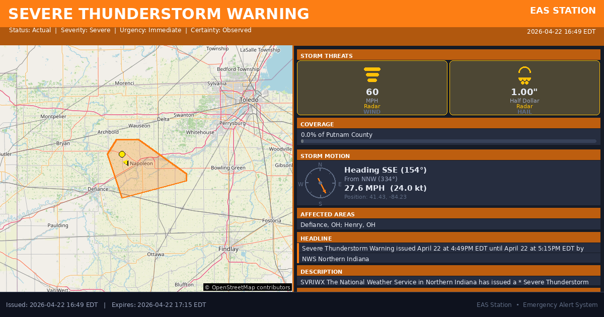
Severe Thunderstorm Warning issued April 22 at 4:49PM EDT until April 22 at 5:15PM EDT by NWS Northern Indiana
Event Type
Severe Thunderstorm WarningStatus
Actual EXPIREDSeverity
SevereUrgency
ImmediateCertainty
ObservedMessage Type
AlertDescription
SVRIWX
The National Weather Service in Northern Indiana has issued a
* Severe Thunderstorm Warning for... Northeastern Defiance County in northwestern Ohio... Central Henry County in northwestern Ohio...
* Until 515 PM EDT.
* At 449 PM EDT, a severe thunderstorm was located near Napoleon, moving southeast at 30 mph.
HAZARD...60 mph wind gusts and quarter size hail.
SOURCE...Radar indicated.
IMPACT...Hail damage to vehicles is expected. Expect wind damage to roofs, siding, and trees.
* Locations impacted include... Napoleon, Mcclure, Malinta, Florida, Grelton, Okolona, Ridgeville Corners, Gerald, Elery, and Standley.
Instructions
For your protection move to an interior room on the lowest floor of a building.
Affected Areas
039039
Defiance County, OH
039069
Henry County, OH
OHC039
OHC069
This covers a small portion of emergency service districts, townships, and municipalities within the county.
Alert Coverage Map
Loading map...
Loading alert coverage map...Timing
04:49 PM EDT
05:15 PM EDT
04:51 PM EDT
06:09 PM EDT
Times in America/New_York. Auto-adjusts for daylight saving.
Technical Details
urn:oid:2.49.0.1.840.0.04ed6173433b750e2882e92075f9ee8ba136c7a2.001.1
#535
Source times converted from NWS format to local Eastern Time.
Affected Boundaries
Localized County Impact
This alert covers 0.0% of Putnam County , affecting some emergency service boundaries.
No Boundary Intersections Found
This alert may not intersect with any configured emergency service boundaries.
NOAA Alert Details
Alert Origin
w-nws.webmaster@noaa.gov
en-US
https://api.weather.gov/alerts/active?zone=OHC003,OHZ016,OHC137,OHZ025,OHZ004,OHC039,OHZ017,OHC063,OHZ005,OHC069,OHZ015,OHC125,OHZ024,OHC161,OHZ006,OHC173
NOAA
EAS Parameters
WXR
— National Weather Service
Geocodes
039039
Defiance County, OH
039069
Henry County, OH
OHC039
OHC069
OHC039
OHC069
Event Codes
SVR
SVW
VTEC
/O.NEW.KIWX.SV.W.0121.260422T2049Z-260422T2115Z/Event Lifecycle (2 alerts)
Storm Motion
Severe Threats
NWS Parameters
SVRIWX
WUUS53 KIWX 222049
2026-04-22T17:15:00-04:00