Alert Details
Alert Information 47.1% County Coverage
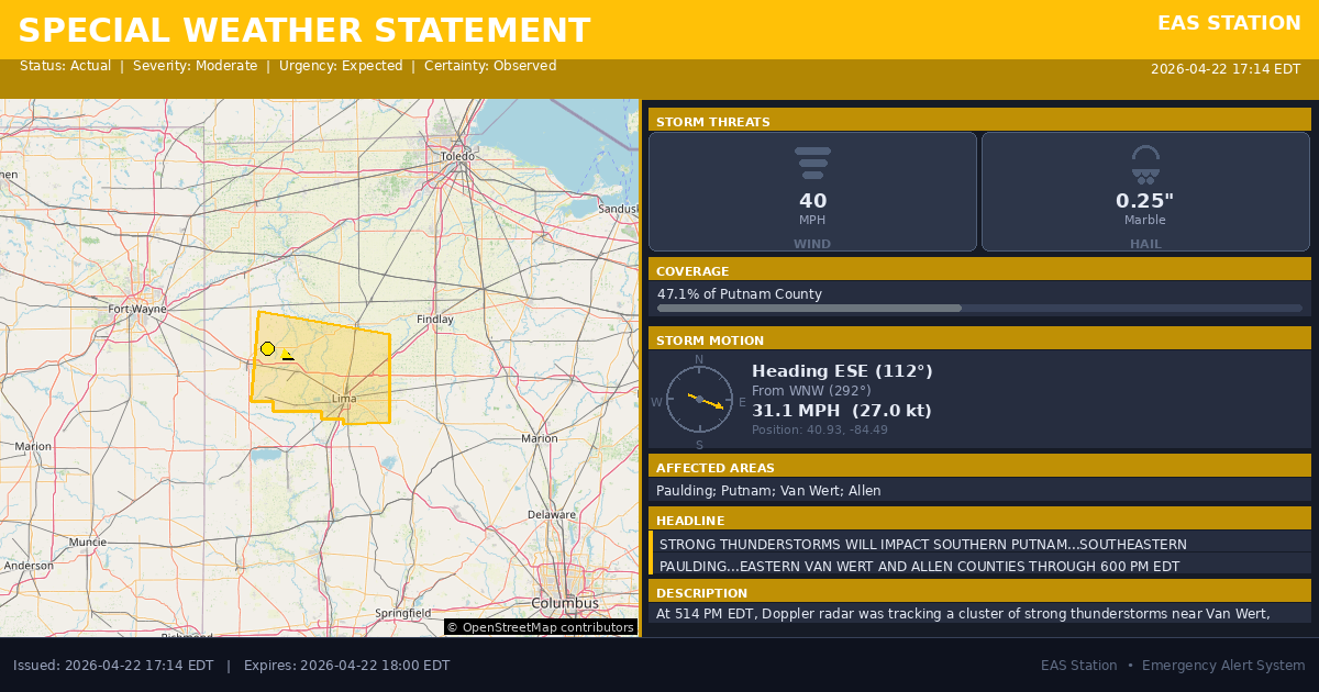
Special Weather Statement issued April 22 at 5:14PM EDT by NWS Northern Indiana
Event Type
Special Weather StatementStatus
Actual EXPIREDSeverity
ModerateUrgency
ExpectedCertainty
ObservedMessage Type
AlertDescription
At 514 PM EDT, Doppler radar was tracking a cluster of strong thunderstorms near Van Wert, moving east at 30 mph.
HAZARD...Wind gusts up to 40 mph and pea size hail.
SOURCE...Radar indicated.
IMPACT...Gusty winds could knock down tree limbs and blow around unsecured objects. Minor hail damage to vegetation is possible.
Locations impacted include... Lima, Delphos, Ottawa, Bluffton, Fort Shawnee, Spencerville, Columbus Grove, Elida, Kalida, Pandora, Ottoville, Spencerville In Allen County, Middle Point, Cairo, Fort Jennings, Harrod, Grover Hill, Beaverdam, Cloverdale, and Venedocia.
This includes Interstate 75 between mile markers 119 and 141.
Instructions
If outdoors, consider seeking shelter inside a building.
Affected Areas
039125
Paulding County, OH
039137
Putnam County, OH
039161
Van Wert County, OH
039003
Allen County, OH
OHZ015
OHZ016
OHZ024
OHZ025
This covers some emergency service districts, townships, and municipalities within the county.
Alert Coverage Map
Loading map...
Loading alert coverage map...Timing
05:14 PM EDT
06:00 PM EDT
05:16 PM EDT
07:19 PM EDT
Times in America/New_York. Auto-adjusts for daylight saving.
Technical Details
urn:oid:2.49.0.1.840.0.f372674bc94fbd79688888cef5eabe75f77ebffa.001.1
#540
Source times converted from NWS format to local Eastern Time.
Affected Boundaries
Localized County Impact
This alert covers 47.1% of Putnam County (~227.9 sq mi) , affecting some emergency service boundaries.
Boundary Analysis Pending
Alert geometry exists (47.1% county coverage), but service boundary intersections have not been calculated yet.
NOAA Alert Details
Alert Origin
w-nws.webmaster@noaa.gov
en-US
https://api.weather.gov/alerts/active?zone=OHC003,OHZ016,OHC137,OHZ025,OHZ004,OHC039,OHZ017,OHC063,OHZ005,OHC069,OHZ015,OHC125,OHZ024,OHC161,OHZ006,OHC173
NOAA
EAS Parameters
WXR
— National Weather Service
Geocodes
039125
Paulding County, OH
039137
Putnam County, OH
039161
Van Wert County, OH
039003
Allen County, OH
OHZ015
OHZ016
OHZ024
OHZ025
OHZ015
OHZ016
OHZ024
OHZ025
Event Codes
SPS
SPS
Storm Motion
Severe Threats
NWS Parameters
SPSIWX
WWUS83 KIWX 222114