Alert Details
Alert Information 0.0% County Coverage
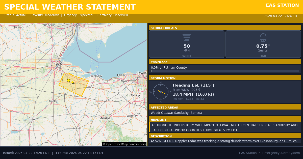
Special Weather Statement issued April 22 at 5:26PM EDT by NWS Cleveland OH
Event Type
Special Weather StatementStatus
Actual EXPIREDSeverity
ModerateUrgency
ExpectedCertainty
ObservedMessage Type
AlertDescription
At 526 PM EDT, Doppler radar was tracking a strong thunderstorm over Gibsonburg, or 10 miles west of Fremont, moving southeast at 20 mph.
HAZARD...Wind gusts up to 50 mph and penny size hail.
SOURCE...Radar indicated.
IMPACT...Gusty winds could knock down tree limbs and blow around unsecured objects. Minor hail damage to vegetation is possible.
Locations impacted include... Fremont, Clyde, Gibsonburg, Woodville, Elmore, Green Springs, Ballville, Pemberville, Bradner, Wayne, Bettsville, Risingsun, Lindsey, Helena, Burgoon, Kansas, Stony Prairie, and Vickery.
Instructions
If outdoors, consider seeking shelter inside a building.
Torrential rainfall is also occurring with this storm and may lead to localized flooding. Do not drive your vehicle through flooded roadways.
Affected Areas
039173
Wood County, OH
039123
Ottawa County, OH
039143
Sandusky County, OH
039147
Seneca County, OH
OHZ006
OHZ007
OHZ008
OHZ018
This covers a small portion of emergency service districts, townships, and municipalities within the county.
Alert Coverage Map
Loading map...
Loading alert coverage map...Timing
05:26 PM EDT
06:15 PM EDT
05:28 PM EDT
07:22 PM EDT
Times in America/New_York. Auto-adjusts for daylight saving.
Technical Details
urn:oid:2.49.0.1.840.0.5c39b51b1a865238e243d06a53451b3bf418e410.001.1
#542
Source times converted from NWS format to local Eastern Time.
Affected Boundaries
Localized County Impact
This alert covers 0.0% of Putnam County , affecting some emergency service boundaries.
No Boundary Intersections Found
This alert may not intersect with any configured emergency service boundaries.
NOAA Alert Details
Alert Origin
w-nws.webmaster@noaa.gov
en-US
https://api.weather.gov/alerts/active?zone=OHC003,OHZ016,OHC137,OHZ025,OHZ004,OHC039,OHZ017,OHC063,OHZ005,OHC069,OHZ015,OHC125,OHZ024,OHC161,OHZ006,OHC173
NOAA
EAS Parameters
WXR
— National Weather Service
Geocodes
039173
Wood County, OH
039123
Ottawa County, OH
039143
Sandusky County, OH
039147
Seneca County, OH
OHZ006
OHZ007
OHZ008
OHZ018
OHZ006
OHZ007
OHZ008
OHZ018
Event Codes
SPS
SPS
Storm Motion
Severe Threats
NWS Parameters
SPSCLE
WWUS81 KCLE 222126