Alert Details
Alert Information 54.2% County Coverage
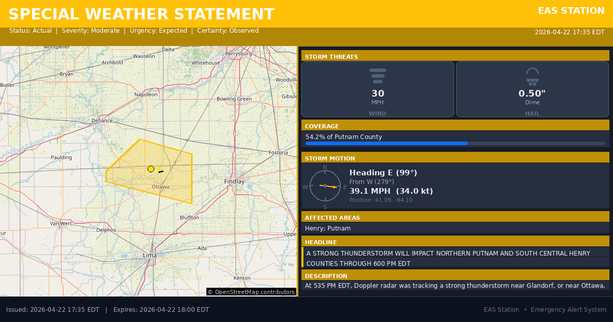
Special Weather Statement issued April 22 at 5:35PM EDT by NWS Northern Indiana
Event Type
Special Weather StatementStatus
Actual EXPIREDSeverity
ModerateUrgency
ExpectedCertainty
ObservedMessage Type
AlertDescription
At 535 PM EDT, Doppler radar was tracking a strong thunderstorm near Glandorf, or near Ottawa, moving east at 40 mph.
HAZARD...Winds in excess of 30 mph and half inch hail.
SOURCE...Radar indicated.
IMPACT...Gusty winds could knock down tree limbs and blow around unsecured objects. Minor hail damage to vegetation is possible.
Locations impacted include... Ottawa, Leipsic, Continental, Glandorf, Dupont, West Leipsic, Gilboa, Belmore, Miller City, New Bavaria, Prentiss, Kieferville, Pleasant Bend, North Creek, and Wisterman.
Instructions
If outdoors, consider seeking shelter inside a building.
Affected Areas
039069
Henry County, OH
039137
Putnam County, OH
OHZ005
OHZ016
This covers some emergency service districts, townships, and municipalities within the county.
Alert Coverage Map
Loading map...
Loading alert coverage map...Timing
05:35 PM EDT
06:00 PM EDT
05:37 PM EDT
07:21 PM EDT
Times in America/New_York. Auto-adjusts for daylight saving.
Technical Details
urn:oid:2.49.0.1.840.0.80769bf83808b0988c17bbb26d965c9f62b2ac4a.001.1
#543
Source times converted from NWS format to local Eastern Time.
Affected Boundaries
Significant County Impact
This alert covers 54.2% of Putnam County (~262.6 sq mi) , affecting many emergency service boundaries.
Boundary Analysis Pending
Alert geometry exists (54.2% county coverage), but service boundary intersections have not been calculated yet.
NOAA Alert Details
Alert Origin
w-nws.webmaster@noaa.gov
en-US
https://api.weather.gov/alerts/active?zone=OHC003,OHZ016,OHC137,OHZ025,OHZ004,OHC039,OHZ017,OHC063,OHZ005,OHC069,OHZ015,OHC125,OHZ024,OHC161,OHZ006,OHC173
NOAA
EAS Parameters
WXR
— National Weather Service
Geocodes
039069
Henry County, OH
039137
Putnam County, OH
OHZ005
OHZ016
OHZ005
OHZ016
Event Codes
SPS
SPS
Storm Motion
Severe Threats
NWS Parameters
SPSIWX
WWUS83 KIWX 222135