Alert Details
Alert Information 0.0% County Coverage
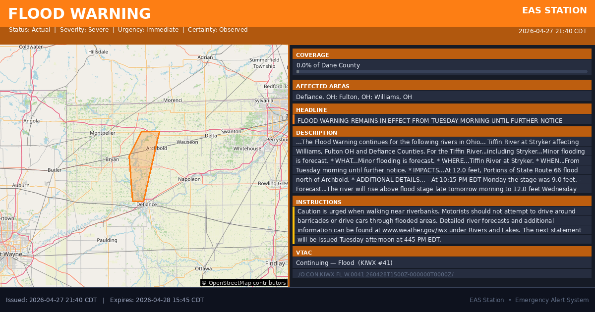
Flood Warning issued April 27 at 10:40PM EDT by NWS Northern Indiana
Event Type
Flood WarningStatus
ActualSeverity
SevereUrgency
ImmediateCertainty
ObservedMessage Type
UpdateDescription
...The Flood Warning continues for the following rivers in Ohio...
Tiffin River at Stryker affecting Williams, Fulton OH and Defiance Counties.
For the Tiffin River...including Stryker...Minor flooding is forecast.
* WHAT...Minor flooding is forecast.
* WHERE...Tiffin River at Stryker.
* WHEN...From Tuesday morning until further notice.
* IMPACTS...At 12.0 feet, Portions of State Route 66 flood north of Archbold.
* ADDITIONAL DETAILS...
- At 10:15 PM EDT Monday the stage was 9.0 feet.
- Forecast...The river will rise above flood stage late tomorrow morning to 12.0 feet Wednesday morning. It will then fall early Thursday morning. It will rise to 12.0 feet Thursday evening. It will then fall again but remain above flood stage.
- Flood stage is 11.0 feet.
- http://www.weather.gov/safety/flood
Instructions
Caution is urged when walking near riverbanks.
Motorists should not attempt to drive around barricades or drive cars through flooded areas.
Detailed river forecasts and additional information can be found at www.weather.gov/iwx under Rivers and Lakes.
The next statement will be issued Tuesday afternoon at 445 PM EDT.
Affected Areas
039039
Defiance County, OH
039051
Fulton County, OH
039171
Williams County, OH
OHC039
OHC051
OHC171
This covers a small portion of emergency service districts, townships, and municipalities within the county.
Alert Coverage Map
Loading map...
Loading alert coverage map...Timing
09:40 PM CDT
03:45 PM CDT
09:42 PM CDT
12:33 AM CDT
Times in America/Chicago. Auto-adjusts for daylight saving.
Technical Details
urn:oid:2.49.0.1.840.0.9e49dcd100bad17d0469d6f25659a8e0a6c6cc13.001.1
#568
Source times converted from NWS format to local Eastern Time.
Affected Boundaries
Localized County Impact
This alert covers 0.0% of Dane County , affecting some emergency service boundaries.
No Boundary Intersections Found
This alert may not intersect with any configured emergency service boundaries.
NOAA Alert Details
Alert Origin
w-nws.webmaster@noaa.gov
en-US
https://api.weather.gov/alerts/active?zone=OHC003,OHZ016,OHC137,OHZ025,OHZ004,OHC039,OHZ017,OHC063,OHZ005,OHC069,OHZ015,OHC125,OHZ024,OHC161,OHZ006,OHC173
NOAA
EAS Parameters
WXR
— National Weather Service
Geocodes
039039
Defiance County, OH
039051
Fulton County, OH
039171
Williams County, OH
OHC039
OHC051
OHC171
OHC039
OHC051
OHC171
Event Codes
FLS
FLW
CAP References
urn:oid:2.49.0.1.840.0.37a0b3f03e0db5eda691df0dafcb5da03ed0dff9.001.1VTEC
/O.CON.KIWX.FL.W.0041.260428T1500Z-000000T0000Z/Event Lifecycle (2 alerts)
NWS Parameters
FLSIWX
WGUS83 KIWX 280240