Alert Details
Alert Information 0.0% County Coverage
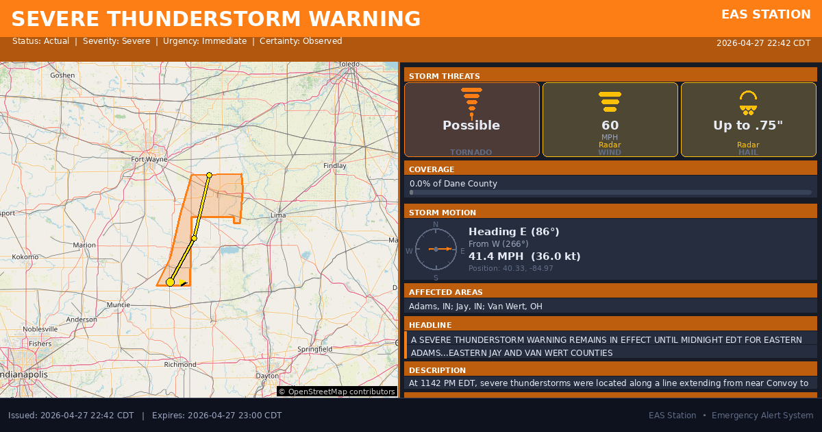
Severe Thunderstorm Warning issued April 27 at 11:42PM EDT until April 28 at 12:00AM EDT by NWS Northern Indiana
Event Type
Severe Thunderstorm WarningStatus
Actual EXPIREDSeverity
SevereUrgency
ImmediateCertainty
ObservedMessage Type
UpdateDescription
At 1142 PM EDT, severe thunderstorms were located along a line extending from near Convoy to 9 miles southwest of Rockford to 7 miles south of Portland, moving east at 40 mph.
HAZARD...60 mph wind gusts.
SOURCE...Radar indicated.
IMPACT...Expect damage to roofs, siding, and trees.
Locations impacted include... Van Wert, Portland, Convoy, Ohio City, Westchester, Middlebury, Middle Point, Dixon, Willshire, Scott, Wren, Salamonia, Venedocia, Elgin, Trinity, Brice, Cavett, Bellfountain, Dull, and Jonestown.
Instructions
Remain alert for a possible tornado! Tornadoes can develop quickly from severe thunderstorms. If you spot a tornado go at once into the basement or small central room in a sturdy structure.
For your protection move to an interior room on the lowest floor of a building.
Intense thunderstorm lines can produce brief tornadoes and widespread significant wind damage. Although a tornado is not immediately likely, it is best to move to an interior room on the lowest floor of a building. These storms may cause serious injury and significant property damage.
Torrential rainfall is occurring with these storms, and may lead to flash flooding. Do not drive your vehicle through flooded roadways.
Affected Areas
018001
Adams County, IN
018075
Jay County, IN
039161
Van Wert County, OH
INC001
INC075
OHC161
This covers a small portion of emergency service districts, townships, and municipalities within the county.
Alert Coverage Map
Loading map...
Loading alert coverage map...Timing
10:42 PM CDT
11:00 PM CDT
10:43 PM CDT
12:35 AM CDT
Times in America/Chicago. Auto-adjusts for daylight saving.
Technical Details
urn:oid:2.49.0.1.840.0.9ce9912f0fe07cec11c424cc6d83d165f068c6b8.002.1
#571
Source times converted from NWS format to local Eastern Time.
Affected Boundaries
Localized County Impact
This alert covers 0.0% of Dane County , affecting some emergency service boundaries.
No Boundary Intersections Found
This alert may not intersect with any configured emergency service boundaries.
NOAA Alert Details
Alert Origin
w-nws.webmaster@noaa.gov
en-US
https://api.weather.gov/alerts/active?zone=OHC003,OHZ016,OHC137,OHZ025,OHZ004,OHC039,OHZ017,OHC063,OHZ005,OHC069,OHZ015,OHC125,OHZ024,OHC161,OHZ006,OHC173
NOAA
EAS Parameters
WXR
— National Weather Service
Geocodes
018001
Adams County, IN
018075
Jay County, IN
039161
Van Wert County, OH
INC001
INC075
OHC161
INC001
INC075
OHC161
Event Codes
SVS
SVW
CAP References
urn:oid:2.49.0.1.840.0.cf8307220b966a930a2a6dd83a67160ba88d364a.001.1VTEC
/O.CON.KIWX.SV.W.0129.000000T0000Z-260428T0400Z/Event Lifecycle (2 alerts)
Storm Motion
Severe Threats
NWS Parameters
SVSIWX
WWUS53 KIWX 280342
2026-04-28T00:00:00-04:00