Alert Details
Alert Information 57.9% County Coverage
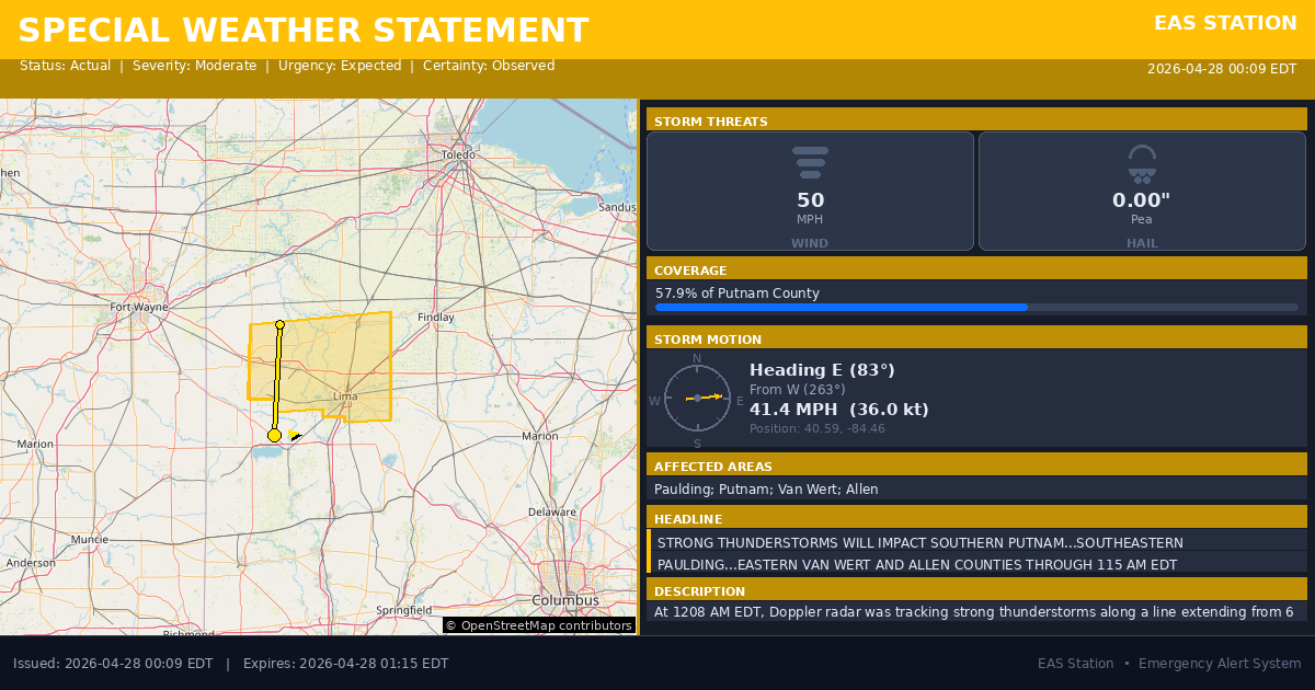
Special Weather Statement issued April 28 at 12:09AM EDT by NWS Northern Indiana
Event Type
Special Weather StatementStatus
Actual EXPIREDSeverity
ModerateUrgency
ExpectedCertainty
ObservedMessage Type
AlertDescription
At 1208 AM EDT, Doppler radar was tracking strong thunderstorms along a line extending from 6 miles northwest of Ottoville to near St. Marys. Movement was east at 45 mph.
HAZARD...Wind gusts up to 50 mph.
SOURCE...Radar indicated.
IMPACT...Gusty winds could knock down tree limbs and blow around unsecured objects.
Locations impacted include... Lima, Van Wert, Delphos, Ottawa, Bluffton, Fort Shawnee, Spencerville, Columbus Grove, Elida, Kalida, Pandora, Glandorf, Ottoville, Spencerville In Allen County, Middle Point, Cairo, Fort Jennings, Harrod, Grover Hill, and Beaverdam.
This includes Interstate 75 between mile markers 119 and 141.
Instructions
If outdoors, consider seeking shelter inside a building.
Torrential rainfall is also occurring with these storms and may lead to localized flooding. Do not drive your vehicle through flooded roadways.
A Severe Thunderstorm Watch remains in effect until 400 AM EDT for west central Ohio.
Affected Areas
039125
Paulding County, OH
039137
Putnam County, OH
039161
Van Wert County, OH
039003
Allen County, OH
OHZ015
OHZ016
OHZ024
OHZ025
This covers some emergency service districts, townships, and municipalities within the county.
Alert Coverage Map
Loading map...
Loading alert coverage map...Timing
12:09 AM EDT
01:15 AM EDT
12:11 AM EDT
02:40 AM EDT
Times in America/New_York. Auto-adjusts for daylight saving.
Technical Details
urn:oid:2.49.0.1.840.0.1c9a7e440a280500a8aa8b3a6b287b4a07510529.001.1
#572
Source times converted from NWS format to local Eastern Time.
Affected Boundaries
Significant County Impact
This alert covers 57.9% of Putnam County (~280.2 sq mi) , affecting many emergency service boundaries.
Boundary Analysis Pending
Alert geometry exists (57.9% county coverage), but service boundary intersections have not been calculated yet.
NOAA Alert Details
Alert Origin
w-nws.webmaster@noaa.gov
en-US
https://api.weather.gov/alerts/active?zone=OHC003,OHZ016,OHC137,OHZ025,OHZ004,OHC039,OHZ017,OHC063,OHZ005,OHC069,OHZ015,OHC125,OHZ024,OHC161,OHZ006,OHC173
NOAA
EAS Parameters
WXR
— National Weather Service
Geocodes
039125
Paulding County, OH
039137
Putnam County, OH
039161
Van Wert County, OH
039003
Allen County, OH
OHZ015
OHZ016
OHZ024
OHZ025
OHZ015
OHZ016
OHZ024
OHZ025
Event Codes
SPS
SPS
Storm Motion
Severe Threats
NWS Parameters
SPSIWX
WWUS83 KIWX 280409