Alert Details
Alert Information 100.0%* County Coverage
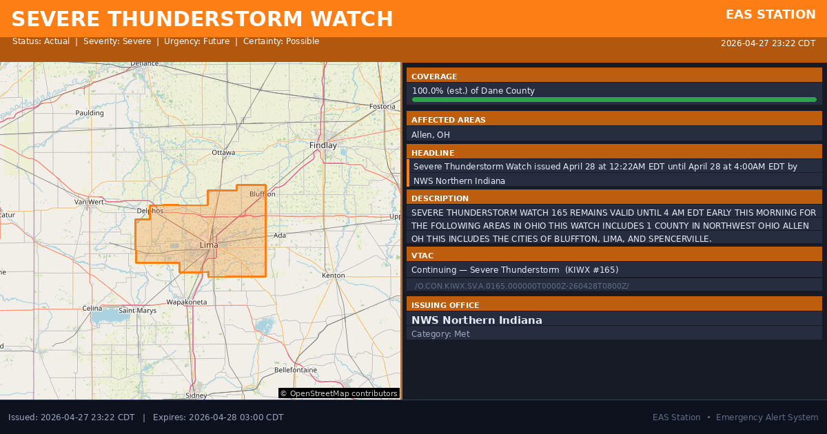
Severe Thunderstorm Watch issued April 28 at 12:22AM EDT until April 28 at 4:00AM EDT by NWS Northern Indiana
Event Type
Severe Thunderstorm WatchStatus
ActualSeverity
SevereUrgency
FutureCertainty
PossibleMessage Type
UpdateDescription
SEVERE THUNDERSTORM WATCH 165 REMAINS VALID UNTIL 4 AM EDT EARLY THIS MORNING FOR THE FOLLOWING AREAS
IN OHIO THIS WATCH INCLUDES 1 COUNTY
IN NORTHWEST OHIO
ALLEN OH
THIS INCLUDES THE CITIES OF BLUFFTON, LIMA, AND SPENCERVILLE.
Affected Areas
039003
Allen County, OH
OHC003
This covers virtually all emergency service districts, townships, and municipalities within the county.
Alert Coverage Map
Loading map...
Loading alert coverage map...Timing
11:22 PM CDT
03:00 AM CDT
11:23 PM CDT
11:48 PM CDT
Times in America/Chicago. Auto-adjusts for daylight saving.
Technical Details
urn:oid:2.49.0.1.840.0.d73680f3d5ff1cf01ee31e26c58237df105304f7.002.1
#573
Source times converted from NWS format to local Eastern Time.
Emergency Service Coverage - All County Boundaries
Major County Impact
This alert covers 100.0% of Dane County (~407.0 sq mi) , affecting most emergency service boundaries.
Coverage estimated from SAME broadcast area. Recalculate intersections to use the storm polygon.
Boundary Analysis Pending
Alert geometry exists (100.0% county coverage), but service boundary intersections have not been calculated yet.
NOAA Alert Details
Alert Origin
w-nws.webmaster@noaa.gov
en-US
https://api.weather.gov/alerts/active?zone=OHC003,OHZ016,OHC137,OHZ025,OHZ004,OHC039,OHZ017,OHC063,OHZ005,OHC069,OHZ015,OHC125,OHZ024,OHC161,OHZ006,OHC173
NOAA
EAS Parameters
WXR
— National Weather Service
Geocodes
039003
Allen County, OH
OHC003
OHC003
Event Codes
SVA
SVA
CAP References
urn:oid:2.49.0.1.840.0.b4de43c0f789e1aad49b58bbd0f5bf8c89ed4094.002.1urn:oid:2.49.0.1.840.0.7c9f232be7cb3acfedbc4d159b07baf9f99c473c.002.1VTEC
/O.CON.KIWX.SV.A.0165.000000T0000Z-260428T0800Z/Event Lifecycle (3 alerts)
NWS Parameters
WCNIWX
WWUS63 KIWX 280422
2026-04-28T04:00:00-04:00