Alert Details
Alert Information 100.0% County Coverage
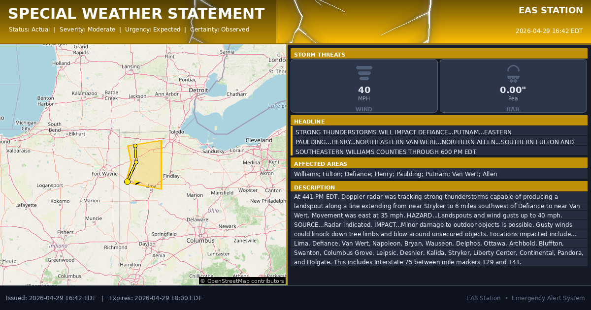
Special Weather Statement issued April 29 at 4:42PM EDT by NWS Northern Indiana
Event Type
Special Weather StatementStatus
Actual EXPIREDSeverity
ModerateUrgency
ExpectedCertainty
ObservedMessage Type
AlertDescription
At 441 PM EDT, Doppler radar was tracking strong thunderstorms capable of producing a landspout along a line extending from near Stryker to 6 miles southwest of Defiance to near Van Wert. Movement was east at 35 mph.
HAZARD...Landspouts and wind gusts up to 40 mph.
SOURCE...Radar indicated.
IMPACT...Minor damage to outdoor objects is possible. Gusty winds could knock down tree limbs and blow around unsecured objects.
Locations impacted include... Lima, Defiance, Van Wert, Napoleon, Bryan, Wauseon, Delphos, Ottawa, Archbold, Bluffton, Swanton, Columbus Grove, Leipsic, Deshler, Kalida, Stryker, Liberty Center, Continental, Pandora, and Holgate.
This includes Interstate 75 between mile markers 129 and 141.
Instructions
If outdoors, consider seeking shelter inside a building.
Affected Areas
039171
Williams County, OH
039051
Fulton County, OH
039039
Defiance County, OH
039069
Henry County, OH
039125
Paulding County, OH
039137
Putnam County, OH
039161
Van Wert County, OH
039003
Allen County, OH
OHZ001
OHZ002
OHZ004
OHZ005
OHZ015
OHZ016
OHZ024
OHZ025
This covers virtually all emergency service districts, townships, and municipalities within the county.
Alert Coverage Map
Loading map...
Loading alert coverage map...Timing
04:42 PM EDT
06:00 PM EDT
04:42 PM EDT
07:12 PM EDT
Times in America/New_York. Auto-adjusts for daylight saving.
Technical Details
urn:oid:2.49.0.1.840.0.97fe6f2ef816f6a701ae8b0ba1af3c0c62f75b13.001.1
#575
Source times converted from NWS format to local Eastern Time.
County-Wide Coverage
County-Wide Impact
This alert covers all configured emergency service boundaries across Putnam County.
NOAA Alert Details
Alert Origin
w-nws.webmaster@noaa.gov
en-US
https://api.weather.gov/alerts/active?zone=OHC003,OHZ016,OHC137,OHZ025,OHZ004,OHC039,OHZ017,OHC063,OHZ005,OHC069,OHZ015,OHC125,OHZ024,OHC161,OHZ006,OHC173
NOAA
EAS Parameters
WXR
— National Weather Service
Geocodes
039171
Williams County, OH
039051
Fulton County, OH
039039
Defiance County, OH
039069
Henry County, OH
039125
Paulding County, OH
039137
Putnam County, OH
039161
Van Wert County, OH
039003
Allen County, OH
OHZ001
OHZ002
OHZ004
OHZ005
OHZ015
OHZ016
OHZ024
OHZ025
OHZ001
OHZ002
OHZ004
OHZ005
OHZ015
OHZ016
OHZ024
OHZ025
Event Codes
SPS
SPS
Storm Motion
Severe Threats
NWS Parameters
SPSIWX
WWUS83 KIWX 292042