Alert Details
Alert Information 0.0% County Coverage
Flood Warning issued April 25 at 10:57AM EDT until April 27 at 8:00PM EDT by NWS Northern Indiana
Event Type
Flood WarningStatus
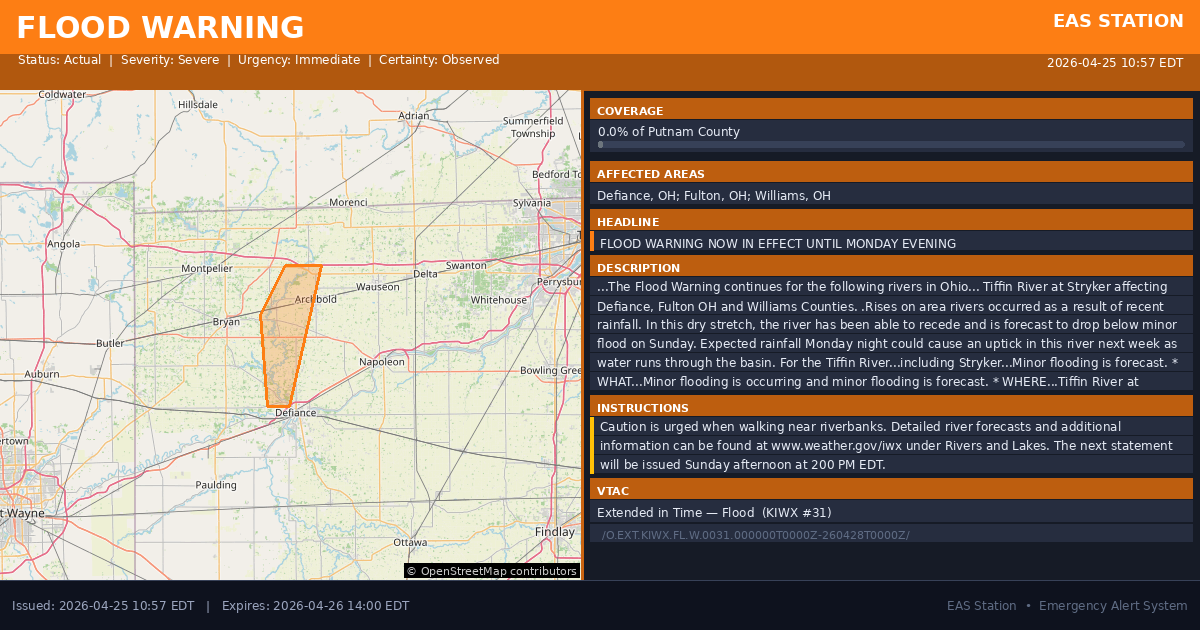
ActualSeverity
SevereUrgency
ImmediateCertainty
ObservedMessage Type
UpdateDescription
...The Flood Warning continues for the following rivers in Ohio...
Tiffin River at Stryker affecting Defiance, Fulton OH and Williams Counties.
.Rises on area rivers occurred as a result of recent rainfall. In this dry stretch, the river has been able to recede and is forecast to drop below minor flood on Sunday. Expected rainfall Monday night could cause an uptick in this river next week as water runs through the basin.
For the Tiffin River...including Stryker...Minor flooding is forecast.
* WHAT...Minor flooding is occurring and minor flooding is forecast.
* WHERE...Tiffin River at Stryker.
* WHEN...Until Monday evening.
* IMPACTS...At 12.0 feet, Portions of State Route 66 flood north of Archbold.
* ADDITIONAL DETAILS...
- At 10:15 AM EDT Saturday the stage was 12.1 feet.
- Recent Activity...The maximum river stage in the 24 hours ending at 10:15 AM EDT Saturday was 12.8 feet.
- Forecast...The river is expected to fall below flood stage tomorrow evening and continue falling to 8.3 feet Thursday morning.
- Flood stage is 11.0 feet.
- http://www.weather.gov/safety/flood
Instructions
Caution is urged when walking near riverbanks.
Detailed river forecasts and additional information can be found at www.weather.gov/iwx under Rivers and Lakes.
The next statement will be issued Sunday afternoon at 200 PM EDT.
Affected Areas
039039
Defiance County, OH
039051
Fulton County, OH
039171
Williams County, OH
OHC039
OHC051
OHC171
This covers a small portion of emergency service districts, townships, and municipalities within the county.
Alert Coverage Map
Loading map...
Loading alert coverage map...Timing
10:57 AM EDT
02:00 PM EDT
10:58 AM EDT
12:40 PM EDT
Times in America/New_York. Auto-adjusts for daylight saving.
Technical Details
urn:oid:2.49.0.1.840.0.f3f027ef6f7177aad6893a89836c8cf21fc3a35e.001.1
#556
Source times converted from NWS format to local Eastern Time.
Affected Boundaries
Localized County Impact
This alert covers 0.0% of Putnam County , affecting some emergency service boundaries.
No Boundary Intersections Found
This alert may not intersect with any configured emergency service boundaries.
NOAA Alert Details
Alert Origin
w-nws.webmaster@noaa.gov
en-US
https://api.weather.gov/alerts/active?zone=OHC003,OHZ016,OHC137,OHZ025,OHZ004,OHC039,OHZ017,OHC063,OHZ005,OHC069,OHZ015,OHC125,OHZ024,OHC161,OHZ006,OHC173
NOAA
EAS Parameters
WXR
— National Weather Service
Geocodes
039039
Defiance County, OH
039051
Fulton County, OH
039171
Williams County, OH
OHC039
OHC051
OHC171
OHC039
OHC051
OHC171
Event Codes
FLS
FLW
CAP References
urn:oid:2.49.0.1.840.0.3b87b4f846f5a9f5f374eef660017c591c48ae47.002.1VTEC
/O.EXT.KIWX.FL.W.0031.000000T0000Z-260428T0000Z/Event Lifecycle (19 alerts)
NWS Parameters
FLSIWX
WGUS83 KIWX 251457
2026-04-27T20:00:00-04:00
w-nws.webmaster@noaa.gov,urn:oid:2.49.0.1.840.0.5fb3faf0f918c2be2d4676232d3fcacc50b60fbb.002.1,2026-04-24T10:05:00-04:00 w-nws.webmaster@noaa.gov,urn:oid:2.49.0.1.840.0.e09782904c1ddc37b340e7f742e8413afa68286e.002.1,2026-04-23T22:06:00-04:00 w-nws.webmaster@noaa.gov,urn:oid:2.49.0.1.840.0.d6e119196a222248f8e183fc77bbae86231b3a15.002.1,2026-04-23T10:29:00-04:00 w-nws.webmaster@noaa.gov,urn:oid:2.49.0.1.840.0.cb95f407ad89274dd21c8f6c6778e15f04643347.001.1,2026-04-22T22:21:00-04:00 w-nws.webmaster@noaa.gov,urn:oid:2.49.0.1.840.0.08c284a8c461f2993cf01cc756c41b1028ca4042.002.1,2026-04-22T16:04:00-04:00 w-nws.webmaster@noaa.gov,urn:oid:2.49.0.1.840.0.b78bb8ea67b137b6d791154af6ae1ad8c253c376.004.1,2026-04-22T10:34:00-04:00 w-nws.webmaster@noaa.gov,urn:oid:2.49.0.1.840.0.7ebc8ff6899877d20f71981b6e73e9f73d2a0bc9.005.1,2026-04-21T22:01:00-04:00 w-nws.webmaster@noaa.gov,urn:oid:2.49.0.1.840.0.ea63128b1ce109178753bdb509dcf14af871c6b4.004.1,2026-04-21T10:10:00-04:00 w-nws.webmaster@noaa.gov,urn:oid:2.49.0.1.840.0.48cd11b352773afce65c75e7e3ac6a6045896cda.004.1,2026-04-21T02:52:00-04:00 w-nws.webmaster@noaa.gov,urn:oid:2.49.0.1.840.0.013875a693476e4595a6a5eb63eb6f89f4a09beb.004.1,2026-04-20T21:22:00-04:00 w-nws.webmaster@noaa.gov,urn:oid:2.49.0.1.840.0.efeef0bd50eaff07529ea07083fa96efd6e29b9f.004.1,2026-04-20T11:49:00-04:00 w-nws.webmaster@noaa.gov,urn:oid:2.49.0.1.840.0.074318623473772df8eedecdd810680908c6ff7e.006.1,2026-04-19T22:12:00-04:00 w-nws.webmaster@noaa.gov,urn:oid:2.49.0.1.840.0.788ba9aa89c1b3151c59a9b969f5aa7c4ddacab0.008.1,2026-04-19T11:37:00-04:00 w-nws.webmaster@noaa.gov,urn:oid:2.49.0.1.840.0.ad1bf11dbbe9d1f325832ab77b03c26615dda32f.009.1,2026-04-18T21:53:00-04:00 w-nws.webmaster@noaa.gov,urn:oid:2.49.0.1.840.0.a779e5ed167c002eb89d843895cd1753b51b14ad.003.1,2026-04-18T16:09:00-04:00 w-nws.webmaster@noaa.gov,urn:oid:2.49.0.1.840.0.d1ccff6aa53abbb560468203e2ea9b597bcef463.009.1,2026-04-18T12:43:00-04:00 w-nws.webmaster@noaa.gov,urn:oid:2.49.0.1.840.0.814931b07eeb471158acfe0e11a21486165f2319.007.1,2026-04-17T22:34:00-04:00 w-nws.webmaster@noaa.gov,urn:oid:2.49.0.1.840.0.aa052b5bbf05e96a52f3d79beade99892656e544.003.1,2026-04-17T21:30:00-04:00 w-nws.webmaster@noaa.gov,urn:oid:2.49.0.1.840.0.bb2a41d20fb21a6f3fc4f00edd8afeb432a7f649.005.1,2026-04-17T11:45:00-04:00 w-nws.webmaster@noaa.gov,urn:oid:2.49.0.1.840.0.f049d8e176ecba0f0d529c1d0e016ed1084893c6.008.1,2026-04-16T11:54:00-04:00 w-nws.webmaster@noaa.gov,urn:oid:2.49.0.1.840.0.99d05b9527e8185f25c2c103ec8df36b3531b20a.001.1,2026-04-15T22:59:00-04:00 w-nws.webmaster@noaa.gov,urn:oid:2.49.0.1.840.0.3614703ac059282cf1519ace7384a308b55f3404.001.1,2026-04-15T11:08:00-04:00 w-nws.webmaster@noaa.gov,urn:oid:2.49.0.1.840.0.e4e3fded3a015ebe0451c60b140925d7b2d3c85a.001.1,2026-04-14T10:47:00-04:00